 |
| Sketch of Scafell Pike |
Sunday, 26 May 2013
Sketch of Scafell Pike
This is a recent sketch I have made of Scafell Pike. It shows the western flank of Scafell Pike from the perspective of Wasdale. You can see the impressive rock face of Pikes Crag above Hollow Stones, below the main summit.
When I did a fell walk on Scafell Pike in August 2006, I followed the path down from the summit to the ridge of Mickledore on the far right of this sketch. I then climbed down the steep section of scree to the right of the impressive rock face featured in the centre of the picture.
Monday, 20 May 2013
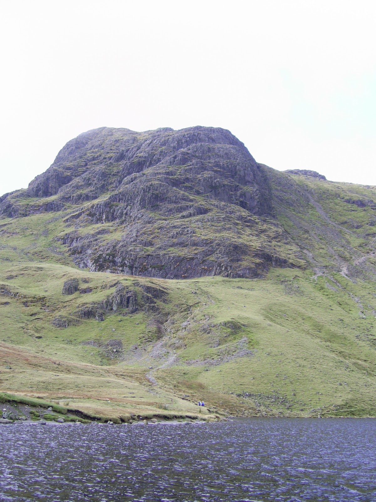
Pavey Ark
Here's a sketch that I have recently done of Pavey Ark. It's taken from the walk I did in November 2009. The route I took that day started from the car park next to the Stickle Barn in Great Langdale, up to the Stickle Tarn, and then made the ascent to Park Ark via Jack's Rake. The view of Pavey Ark in this Sketch is taken from across Stickle Tarn where I took a brief rest after making the steep ascent up from the valley below. You can see the diagonal line of Jack's Rake going up the cliff face from the bottom right of the sketch, up to the pinnacle towards the top left of the cliff face.

Friday, 17 May 2013
The Howitzer, Helm Crag
I have had the pleasure of climbing Helm Crag on three separate occasions. The first was circa 1983 when I went camping with a small group from School. We were based in a farmers field on the lowers slopes of Seat Sandal, and had a fantastic view from across the valley.
The second walk we did that week took us up the quiet Greenburn Bottom valley between Steel Fell and the Gibson Knott ridge. We ascended Calf Crag at the top of the valley before walking back via Gibson Knott. The last fell we came that day was Helm Crag which stood at the end of the ridge that we had walked along. I remember being impressed by the rock formations, although none of our party climbed the summit rocks often referred to as The Howitzer.
It wasn't until 2007 and then again in 2010 that I ascended Helm Crag alone, and went on to do the short scramble to the top of the Howitzer. This sketch is taken from a photograph I took on the 2010 ascent. It is viewing the Howitzer from the western flank, the side most people see when they arrive at the summit.
 |
| Sketch of The Howitzer, Helm Crag. |
Saturday, 11 May 2013
Sketch of Ill Bell from Red Screes
This sketch is taken from a short walk I did from the top of the Kirkstone Pass to the summit of Red Screes. You can see some of the photographs and a description of this walk here. The view is taken towards the top of the ascent above the Kirkstone Pass. St Raven's Edge can be seen directly across the pass, with the Ill Bell Ridge behind.

Thursday, 9 May 2013
Pencil Sketch of Great Gable
This is a sketch of I made of Great Gable within the last few days. I had the pleasure of doing a walk on this fell back in Easter 2006. It was a sunny clear day, which offered some amazing views along the route which I took from Seathwaite in Borrowdale. You can read a full account of the this Great Gable Walk here.
This sketch shows Great Gable from the perspective of Kirk Fell. It is actually taken from a photograph by Ann Bowker which I particularly like (I didn't own a camera back in those days!). You can see Great Gable standing majestically in the centre, with Green Gable and Great End in the background to it's left and right respectively.

This sketch shows Great Gable from the perspective of Kirk Fell. It is actually taken from a photograph by Ann Bowker which I particularly like (I didn't own a camera back in those days!). You can see Great Gable standing majestically in the centre, with Green Gable and Great End in the background to it's left and right respectively.
Saturday, 22 October 2011
Red Screes from the Kirkstone Pass 5/9/10
This walk began from the car park opposite the Kirkstone Inn at the top of the Kirkstone Pass. The beauty of this walk was the easy accessibility to the high fells - the complete opposite of the walk I did to Scafell Pike a couple of years earlier. This was particularly useful today, when I had limited time.
When I started the Red Screes walk I was already 1493ft above sea level, and rocky ascent to Redscrees summit loomed above me. I only had to pass a gate in the wall at the end of the car park, and on the opens fells.
I crossed a short boggy section of ground and began the ascent. I quickly gained height and before long I was look back down to the Kirstone Pass. I got a great view of the Kirkstone Inn and the car park where I had begun my walk.
As I climbed further I could see over St Raven's Edge to the Ill Bell ridge.
After a few short sections of easy rocky scrambling (nothing like Jack's Rake or Sharp Edge), the ascent began to flatten out and in just less than an hours walking I had reached the summit of Red Screes.
The view from the summit was amazing. To the north, I look over Middle Dodd down into Patterdale where I could see Brotherswater and a small snippet of Ullswater further down the valley.
Looking north west I could see the Fairfield range with the fells of Helvellyn behind.
I could also see Lake Windermere to the south:
And more of the Ill Bell ridge looking east:
When I started the Red Screes walk I was already 1493ft above sea level, and rocky ascent to Redscrees summit loomed above me. I only had to pass a gate in the wall at the end of the car park, and on the opens fells.
 |
| The ascent to Red Screes summit seen from the Car Park at the start of the walk. |
 |
| Looking back down to the Kirstone Inn from the steep ascent to Red Screes. |
 |
| St Raven's Edge in the foreground with the peak of Ill Bell seen behind. The Kirkstone Pass is in front and below St Raven's Edge just out of shot. |
 |
| Approaching the summit cairn of Red Screes. |
 |
| View north from Red Screes Summit. Middle Dodd is the fell in the foreground. Brotherswater is directly behind. |
 |
| View of the Fairfield and Helvellyn range, north west from Red Screes Summit. |
 |
| Lake Windermere from Red Screes. |
 |
| Ill Bell and the Kentmere ridge. |
Thursday, 30 September 2010
Pavey Ark via Jack's Rake (November 2009)
I started this walk around 10am from the pay and display car park next to the Stickle Barn near the New Dungeon Gill Hotel. It was a cold but sunny November morning in the picturesque valley of Great Langdale. There was a great view of the lower fells on either side of Stickle Gill which hardly get mentioned on the OS Explorer Map. They looked like interesting fells in their own right, but are dramatically over shadowed by the Langdale Pikes. From the car park the Pikes are largely obscured by the steep sides of the valley.
I set off up the footpath which went through a wooded area beside Stickle Gill, and followed the path by the steam crossing to the eastern bank a little further up. The slopes leading up to Stickle Tarn looked a glorious golden brown under a shinning sun in the cold crisp air. Above me to my left was was Pike How and to my right were the rocks of Langdale's Tarn Crag. As I continued up the path it began to get rocky and involved some light scrambling. I decided to cross back over the boulder strewn stream, which was flowing deep and fast today. It seemed much more difficult on this occassion, compared to my last crossing at the same point two years earlier.
As I completed the last section of the climb, the grand site of Pavey Ark came into view.

As the ground levelled out Stickle Tarn also came into view along with the wall that runs along the southern edge. I decided to take a rest after the steep ascent, and went to sit on the wall and take in one of the most impressive views in the Lake District.
 |
Straight ahead of me was the massive cliff face of Pavey Ark across Stickle Tarn, and to my left was the eastern shoulder of Harrison Stickle, the highest of the Langdale Pikes. As I sat there, I surveyed the diagonal line of Jack's Rake, starting at the lower right hand side of the Pavey Ark's cliff, going upwards to the left, and ending at the small pinacle. It looked a somewhat formidable sight, and I couldn't help feeling a slight sense of apprehension as I viewed the spectacular rock face. In less that thirty minutes I would be starting this ascent myself.
I made my way around the south-western corner of the tarn, turning off the main path which went up to Harrison Stickle, and followed the bank of the water. As I went on, the dark cliffs of Pavey Ark loomed up overhead across on my left. I veered away from the side of the water and started to climb across the large boulders and scree to the start of Jacks Rake. It seemed rather dark, damp, and cold as I got up close.
 |
| The start of Jack's Rake. Notice the small group just setting out centre right. There is also a lone scrambler part way up. |
I eventually made it to the start of the Rake. I started the initial section which involved a reasonable easy scramble inside a groove in the rock which was about a meter wide. The rock wall of Pavey Ark was too my right, whilst to my left there was a low natural parapet with some vegetation growing on it. It was almost like going up a staircase. Things soon started to get more difficult though. When I first started I could see a group higher up the rake just before the "path" turned round a curve in the rock and went out of sight. They seemed to be hardly moving, and I thought I would soon catch them up. This did not happen though. As I approached this steeper section of the Rake, I found it technically challenging, with suitable foot and hand holes difficult to find as I made my way upwards. Some which I was forced to used seemed to be barely cracks in the rock which I normally would not attempt to use, but this was all there was, and once I had started to climb it was easier to continue up than to retreat back down. I had certainly let myself in for something much more difficult than what I had imagined. It was slow going. I gradually made my way upwards,with each movement carefully thought out and tested in advance, until I made it to a flat ledge above an Ash tree growing out of the cliff below.
 |
| This photo was taken at the top of the first section of the Rake. It is a bit deceptive in as much as it doesn't give a sense of the steep climb required to get to this point. The near vertical section of climb is hidden below the ledge left of the Ash tree. On the right there is a vertical drop. |
This had been the steepest sustained section of the rake. Further along there were more level sections, some along narrow exposed ledges above steep grass slopes that lead down to vertical drops down the crag face. There were still many shorter sections of steep climb which I found rather challenging. One of these was, for me, particularly scary. After traversing one of the level sections of ledge, there was a steep climb that seemed to be just above a vertical drop down to the scree above the tarn. This seemed to be the most exposed section of the rake. I really had to force myself to do this part. I was at this point acutely aware of how high I was on the rock face, and it did feel much more like rock climbing than scrambling.
After negotiating a number of other difficult (although not quite as traumatic) sections, I came round a bend in the rock, and saw a wide rock gully running down the face of the crag, relatively easy to scramble across. I knew at this point that this was Great Gully, and this marked the final section of the Rake. I could see the Pinnacle above, a bit further ahead.

I read in Wainwright that I needed to head for the depression just to its right. To get there I needed to pick my way though sections of rock and vegetation. Finding a way through was more difficult than the photograph above suggests. Once I had crossed the gully and got up close to the rocks, it wasn't obvious which climbs led to ledges from where I could continue climbing safely. At one point I climbed up onto a ledge adjacent to a huge slab of slanting rock. Normally it could have been crossed, but on this occasion it was too wet and slippy to grip. In order to continue it was necessary to climb back down to the lower ledge and use a different route up the rock. Once I had done this I had reached the side of the pinnacle where there was flat rock. This was the end of Jacks Rake. I felt a deep sense of relief to have made it.
From here I made my way over the last sections of rock to the summit of Pavey Ark where I sat down to take in the incredible views.
 |
| Looking across from Pavey Ark summit to Harrison Stickle. |
 |
| Looking from Pavey Ark summit across the ridge leading to Pike o' Blisco to the Coniston Fells. The rocky slope on the right is the east shoulder of Harrison Stickle. |
I have to admit the ascent of Jacks Rake had been a difficult and traumatic climb for me. It had tested my scrambling abilities even though I have had previous experience of rock climbing. It was, however, a fantastic experience, and one which I would very much like to do again. It wasn't until the next day when I truely realised this. But as I sat there on the summit of Pavey Ark, I did at that moment feel emotionally exhausted, despite the fantastic views, which I still managed to appreciate.
I finished the walk by making my way along the path to Harrison Stickle where I spent some time on the summit taking in the views across the Great Langdale Valley. On the descent I took the path above the steep ravine of Dungeon Ghyll, another spectacular sight, before following the path down the steep slope to Pike Howe, and back to the car park at the Stickle Barn.
Subscribe to:
Posts (Atom)

